Cooksburg, PA - Cooks Forest
State Park
River Road along the Clarion River, PA
I first became aware of the Clarion River and the roads that snake along
its banks and cut up through the forest and over the ridges in the mid-1960s
when, as a summer camper with the YMCA, I signed up for canoe trips and learned
to love this region of Pennsylvania. In years later, I returned to the area
with school friends and girlfriends to hike the roads and trails, camp in the
dense pine forests and navigate the meandering reaches of the river by canoe.
 |
|
The Clarion stretches across north central Pennsylvania cutting a
crooked path through the mountain ridges and along the valleys to where it
flows into the Allegheny River. From the Allegheny River confluence, the river
traces upstream through Clarion County to the place where the river forms the
boundary between Forest and Jefferson counties, and later between Elk and
Jefferson counties. Then where the Elk-Jefferson county line turns southeast,
the river continues through the heart of Elk County on its north easterly run
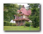
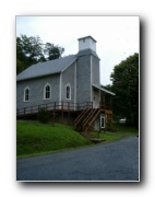
through the towns of Ridgeway and Johnsonburg. Victorian houses and small
clusters of businesses, churches and cemeteries fill the hollows where the road
descends from the ridges to the river valleys below. |
But this is a description of the road, not the river. River Road traces
the course of the river between the upstream town of Hallton and Cooksburg at
the junction of Clarion, Forest and Jefferson counties. This 21 mile road
meanders with the river, intermittently following close to the bank and high on
the slopes that sheds its snow melt into the river. The surface conditions
range from new or well worn asphalt to well packed gravel. Most of what was
gravel is now paved. Grades at times become steep, but altogether it is a grand
ride.
|
It rained all the night the day we set out for Cooksburg. The
morning was soggy but the day promised to clear up later. As we set out for the
northern part of the state, the rain returned and poured almost all the way up.
I had decided that we should continue regardless of the weather to reconnoiter
the area anyway after the long absence from the area. A few time the cloud
cover teased us with intervals of sunshine then dashed those hopes with renewed
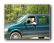
precipitation. On this trip, my mother and her German Shorthair Pointer were my
SAG team so that a return along the meandering road would not be necessary.
Virginia and Tory are truly a team, being inseparable except for a few hours at
a time for necessary chores and errands. For the longer trips away from home,
the Cozy Inn is Tory's home away from home. In this extended outing, she minded
her own affairs on the floor in the back next to the trike.
|
|
 |
The two hours driving north seemed longer with the rain and the slow
going in the diminished visibility of torrents of rain and window condensation.
Finally, as Cooksburg came into view, the vague recollection of the turnoff to
River Road crystallized in my mind and we turned off Route 36 to follow the
river.
Accessibility comes even to the rural woodlands of North
Central Pennsylvania |
The incessant rain had the
whole place hunkered down and out of sight. There was no one around to be seen.
Even as we drive the first 13 miles along the road, not even a car or truck
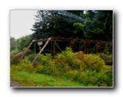
passed us or was passed by us the whole time. Then part way to Hallton, there
was a construction site where one of the very few river crossing bridges was
being replaced and upgraded. Deep areas of mud abounded, so that limited the
length of any possible rides for the day to the first 13 miles and not longer.
The van even had difficulty slipping through the zone. |
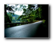
New asphalt hides the old character
of the river
road.
|
By 4:00 the rain had relented and a few unfamiliar dry spots on the
pavement began to appear. After looping around from the trip limits in Hallton,
we came back to where there was a convenient "trailhead" from which to launch
the boat, oh, I mean get out the trike and set off along the road. The
afternoon sun immediately raised humidity and a dense feeling atmosphere that
weighted heavily in my lungs as I started off on the last 8 miles before
reaching Route 36 back at the turnoff. The earthy smell of damp rich pine
forest and natural gas filled the air as I cruised in the down stream
direction. Pine smells and the gas emanated from the forest. The pine odors are
self explanatory, but the gas needs a bit of explanation. About 20 feet or so
back from the road and as far up in elevation along the steep slope of the
mountainside there is a 2.5 inch steel natural gas pipe that serves a few
isolated customers who live along this idyllic stretch of byway. It rests
directly on the surface of the ground and rests against the roots of trees on
the high-side. Over the years, a few pin-holes or coupling leaks let escape
just enough gas to be detected by nose but not enough so as anyone is willing
to repair the problem. All and all it is not a bad leak problem.
|
The last part of the river (and River Road) make long wide
meanders that obscure the road ahead and alternately reveal its nature. The
ride lasted only about one hour but the clearing skies did bring out the
dormant riders and hikers. By the time I rolled in to parking lot by the
highway, there were dozens of people just beginning their treks for the day.
Smoky cook fires filled the air with aromas of charcoal and the better scents
of pine bark. With the short ride now done we headed home to Pittsburgh and
back into the rainy skies and setting sun, where ever it was. |
|
 |
Autumn would be a good time to return to Cooks Forest and end the ride
with a waiting meal and a warm fire prepared by the SAG driver who has to mind
the equipment and not make the ride.
Copyright 2004, ModalChoice
View
whole trip album - Click Here